
PNN – The war machine and mass killing of Zionism in the region has faced numerous and serious obstacles in such a way that a number of Zionist possessions in the “satellite” sector have recently gone out of orbit and America has come to their aid to compensate for their deficiencies.
While the Zionists failed to implement their declared goals in the Gaza Strip, they opened a new front in Lebanon in order to somehow reduce the severe pressure of global public opinion. Despite some tactical victories of the Zionist regime at the beginning of the Lebanon conflict and the martyrdom of a number of Hezbollah leaders, the Zionist war machine is now facing numerous and serious shortcomings and obstacles; Among the vital capabilities needed by the Zionists in this war are space-based capabilities such as “satellite”.
In this report, we will explain the capabilities of Israel’s satellite technology and show why America is ready to help the Zionist regime with all its might, considering the problems of the Israeli regime in this sector.
The importance of space and satellite development
The use of space capacities to strengthen and advance national interests is considered one of the very basic and sensitive areas of science production and technology development. In other words, the countries that are trying to develop their space capabilities should actually develop several important scientific fields at the same time. And apart from significant financial resources, it must have great support and scientific capacity in order to be able to establish an effective connection between these various sectors and finally take advantage of the opportunities available in space for the benefit of its goals, interests and national security.
Among the space capabilities, satellites are among advanced technologies. The development and exploitation of satellites began and expanded in a tangible way during the Cold War years, and a significant part of satellite developments around the world took place in these years. The main actors of this period were the United States and the Soviet Union and some of their satellite countries.
Read more:
The Guardian: Israel used US-made bombs in the deadly Beirut attack
Examining the history of this area is beyond the scope of this report, and here we will limit ourselves to stating a few points related to the main topic of the report.
Satellites can be classified into the following categories based on their application:
Information satellites
These satellites are placed in different earth orbits to collect different types of data. Collecting radio waves at different frequencies, ecological information, weather, etc. are some of the types of information that these satellites collect.
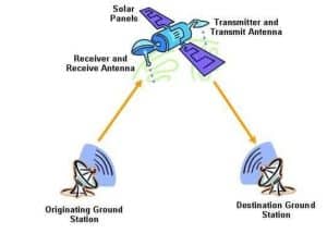
Communication satellites
The purpose of placing these satellites in the earth’s orbit is to establish and maintain telecommunication and internet communications. These satellites are also used for early warning of natural and human disasters.
Imaging satellites
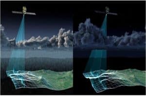
These satellites provide many images of the Earth’s surface and subsurface, which are available in two main types: optical and radar (SAR). These satellites have developed amazingly and provide high-quality images even in adverse weather conditions, from the surface and subsurface of the earth.

Satellites are used “individually” and in the form of “system”. The performance of individual satellites is clear and does not need explanation. But the meaning of satellite systems is that a certain number of satellites are placed in a single orbit around the earth at the same time or at a short distance and are connected to each other and cover the entire surface of the earth. The use of satellite systems in all three applications is common. Of course, most of the satellite systems have military and spy applications.
In the field of satellite imaging of the earth, the situation is different and the number of private companies active in the field of satellite imaging is very large and significant. This abundance has gone so far that now even governments such as America, India and France go to private companies active in this field to provide the satellite images they need.
Military use of satellites
In today’s battlefields of the world, in the absence of space-based facilities, it is difficult to be victorious on the battlefield. Although such facilities cannot necessarily determine the winner of the battlefield alone, their lack is also a big challenge. Satellites have two main uses in the battlefield:
_ Gathering information, identification, surveillance and targeting
_ Communication, navigation and route discovery
These two main uses are for ground, sea and air forces as the basic resources of war. In other words, as much as weapons and ammunition are necessary to advance a battle, benefiting from space-based facilities, such as satellite photos of the surface and subsurface of the battlefield, stable communications between command centers and scientific units, discovering the exact location of enemy targets, etc… are also of vital importance.
In general, all satellites placed in different orbits of the earth can have dual use; For example, the capacities of telecommunication satellites can be used for military purposes when necessary, but only a few countries in the world have placed satellites in the earth’s orbit specifically for military purposes.
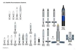
The table below shows these countries along with the number of their military satellites. The interesting point is that despite the all-round pressures of the global arrogance system against the government and nation of Iran, our country is also one of the members of this table, while no trace of the rich countries of the region or apparently advanced European countries can be seen in this table.
Space-based capabilities of the Zionist regime against the axis of resistance
The Lebanese Hezbollah’s pressure on the Zionists in the northern parts of the occupied territories with the aim of reducing the crimes committed by the Zionists against the Palestinian civilians in Gaza and the West Bank caused the regime to open another front in Lebanon.
The resistance of Yemen and Iraq also joined the Lebanese and Palestinian fighters, but the Zionists have not yet opened a specific and official battle front against these two countries and only carry out air attacks. Iran, as one of the important elements of the axis of resistance, since the beginning of the Al-Aqsa storm, has brought that part of its capacities to the field in support of this axis. And in the two operations of the True Promise, one and two, it directly targeted the military centers of the Zionists in the occupied territories from its own soil.
The Zionist spying and intelligence agencies are under severe pressure due to the conflict on several fronts, and many agents and experts of the Zionist and American intelligence affairs have claimed that after the end of this story, the Zionist intelligence organization must be completely rearranged and modernized.
A significant part of the intelligence and security capabilities of the Zionist regime in this battlefield relies on satellite facilities and technologies that are either created by itself or provided by its American and European sponsors. The serious weaknesses of the Zionist regime in facing the axis of resistance make it necessary to use these facilities.
The Zionist army needs satellites in the following cases:
_ Identification of the command centers and locations of operational units of the resistance forces in Gaza, West Bank and Lebanon
_ Discovery of tunnel networks of resistance forces in Gaza and Lebanon
_ Identification of targets with infrastructural and sensitive value in Gaza, Lebanon, Yemen, Syria and Iraq
_Monitoring the sensitive activities of the Islamic Republic of Iran, especially in the missile and drone sector
_ Guiding and locating your operational units in the battlefield of Gaza and Lebanon
_Establishing stable communication with different operational units on the battlefield and in various command centers
Currently, the Zionist Space Agency has put the following set of satellites into orbit and is operating them:
_ Horizon; A collection of intelligence and surveillance satellites, 10 of which are currently in orbit.
_ Amos; A set of low-cost modular optimized communications satellites (AMOS) deployed by the Israeli company Spacecom, three of which are currently in orbit.
_ Eros; Underground resource monitoring satellites (Eros) are a set of commercial satellites owned and managed by the Israeli company ImageSat International N.V. (Image Sat International). Currently, three of these satellites appear to be in Earth orbit.
_ Taksar; this satellite is also known as “Takhsar, Polaris and OFK-8” and is a reconnaissance satellite based on the Artificial Aperture Radar (SAR) technology. This satellite is equipped with the SAR system and is among the most important satellite assets of the Zionists. Satellites equipped with artificial aperture radars (SAR) have the ability to create images behind natural and artificial obstacles.
The Zionist regime, which has intensified its attacks on Lebanon since October 1, has made the military commanders of this regime in dire need of detailed and located satellite images from Lebanon and other regions. Since the first days of summer, the Israeli army has lost a significant part of its space monitoring and surveillance capabilities and has to continue its operations with many restrictions in this sector.
The Zionists have lost three of their satellites due to the need to find an early replacement. OFK 11, one of the two third generation optical satellites, was decommissioned on June 9 (20 June) and OFK 10, one of the two SAR satellites, was decommissioned on July 14. Of course, OFK-5 was also decommissioned in February. OFK-5 was one of the possessions of the Zionists to monitor developments and movements in Iran and Yemen.

Therefore, currently, in addition to the two “very old” optical satellites of the second generation, OFK-7 and OFK-9, which were put into orbit in 2007 and 2010, respectively, and their performance is not sufficient and efficient in the conflicts of the current modern era, the regime army Zionist now can only use three satellites.
OFK-16 was launched in 2020 for optical observation; OFK-13, which will provide radar coverage of the artificial aperture (SAR) from 2023; And the Eros C3-1 satellite (Eros C3-1) belonging to the commercial operator named Image Sat International, which was launched in 2023 and has a performance close to Ofk-11.
The Zionist regime is America’s strategic asset in the region
The form and extent of America’s support to the Zionist regime in the satellite sector explains well why the continued existence of this regime in the Middle East is of strategic importance to America. The pressure of war on several fronts, successive failures on the battlefield, direct attacks by Iran and the decommissioning of a number of sensitive Zionist satellite assets, caused America to import a significant part of its commercial satellite capacities in support of the Zionist regime.
The involvement of American military satellites in different parts of the world, including in the Middle East region and in connection with the axis of resistance, caused the Pentagon and the American intelligence community to request cooperation from important American satellite companies under confidential contracts.
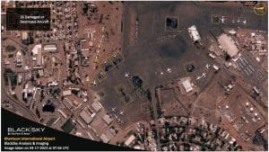
Black Sky is an American private company that owns a system of more than 60 small imaging satellites. This system prepares different types of surface images and sells them in the commercial market. These images are now exclusively provided to the Zionist army through the Pentagon. Back Sky offers the most advanced real-time information platform called Spectra, which is considered a basic space information platform.

“Maxar Technologies” is an American space technology company that specializes in manufacturing and guiding optical satellites and reconnaissance, information and communication radars. This company is actually the result of the combination of two satellite giants of the world, Digital Globe and MDA Holding, which merged in October 2017.
Maksar is among the three main satellite contractors of the Pentagon, and most of the images obtained by this company’s satellite system are first injected into the American intelligence community and then into the Zionist regime.

The importance of satellite images of this region becomes more apparent considering what is not available now. International clients using Maksar’s commercial imagery have reported that almost no new satellite images of key areas in Lebanon are available.
For example, in the months of August and September, only two images of Beirut were available from the Worldview-3 satellites, and the rest of the satellite images from this area were only available to the Pentagon and were not offered commercially.
Summary
It should be noted that these satellite imaging companies are private companies and their facilities and assets are different from the satellite assets of the US military and the Zionist regime. In other words, the current pressure on the Zionist regime, the strategic influence of the United States in the Middle East, has caused the United States to use its satellite capabilities in the private sector to support its military goals and those of the Zionists in the region.
The satellite systems of the two mentioned companies are currently focused on Lebanon, Iran, Yemen, Syria and occupied Palestine. Since a small number of Blacksky and Maksar satellite images are presented in the commercial sector, the satellite images of the Planet Company will be available to the world’s media from October 1, at the same time as the beginning of the brutal bombing of Lebanon by the Zionist regime.
Planet company’s satellite images, despite their abundance, cannot show the current situation in Lebanon well, and consequently, these images are not very important for the security agencies and military organizations of the United States and the Zionist regime.