PNN – The Zionist regime’s plan known as “Greater Jerusalem” and “E1” for settlement construction in Palestinian territories represents a calculated conspiracy to fragment Palestinian residential areas and separate the northern West Bank from its south.
Following the expansion of Zionist settlements in occupied Jerusalem and the displacement of Palestinians from the area, Palestinian and regional circles are warning about the Zionist regime’s conspiratorial plans to alter the demographic and geographic shape of the West Bank through a dual-purpose project aimed at separating the north of the region from its south.
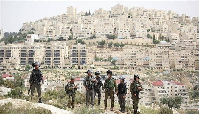
Firas Al-Qawasmi, a Palestinian affairs expert, stated in this regard that according to the Zionist regime’s project to separate the northern West Bank from its south, the occupiers intend to completely isolate East Jerusalem from its Palestinian surroundings and turn Palestinian areas into over 200 separate, enclosed zones without any geographical contiguity.
These facts were revealed after Yoav Gallant, the war minister of the Zionist regime, announced yesterday the start of construction of 1,200 new housing units in the Beit El settlement, located north of Ramallah.
Read more:
One-third of Zionists are suffering from a psychological crisis caused by the war.
The Zionist regime’s war minister also referred to efforts to establish more settlement outposts as part of the so-called “Nachal” project, within broader plans to rebuild settlements and Zionist army bases in the occupied northern West Bank.
Separation of the Northern West Bank from the South
The most concerning information about the “E1” project and the “Greater Jerusalem” project as strategic tools for the Zionist regime to achieve its goals of dominating Palestinian lands is that, according to available information, this project not only intends to seize 12 square kilometers of Palestinian land, but also creates a secure corridor for the Zionist regime connecting the Mediterranean Sea to the Jordan Valley and the Dead Sea.
Contrary to Zionist propaganda claiming that settlements are merely small border outposts, maps published regarding the Zionist regime’s recent decision to expand its settlements indicate that the West Bank is controlled by 4 major settlement blocs (Ariel, Modi’in Illit, Givat Ze’ev, and Ma’ale Adumim) which function as fully integrated cities with complete infrastructure and administrative structures.
Considering field realities, this map shows a complex network of bypass roads extending approximately 1,000 kilometers. These roads connect settlements while simultaneously fragmenting Palestinian territory.
This road network, strengthened by the legalization of new settlement outposts (like Sanur) and other locations deep within the West Bank, has turned Palestinian lands into approximately 235 separate, enclosed areas lacking any geographical or demographic contiguity.